There are several correction services, which differ technically:
- SSR, a “Revolution” for GNSS
- SSR, a “Revolution” for GNSS
- SSR, a “Revolution” for GNSS
- SSR, a “Revolution” for GNSS
- SSR, a “Revolution” for GNSS
- SSR, a “Revolution” for GNSS
- SSR, a “Revolution” for GNSS
- SSR, a “Revolution” for GNSS
- SSR, a “Revolution” for GNSS
- SSR, a “Revolution” for GNSS
SSR, a “Revolution” for GNSS

SSR vs OSR :
A Revolution in High Precision GNSS for Industry
High-precision geolocation is enjoying spectacular growth. GNSS (Global Navigation Satellite System) is now omnipresent in new technologies, responding to growing demand. It is against this backdrop of innovation that a genuine technological revolution is emerging.

…
Autonomous vehicles, drones, smartphones, connected objects… The list of applications requiring centimetre-accurate positioning continues to grow. But is the technology enabling this level of precision ready for large-scale deployment in industry?
Once limited to niche markets requiring high precision, this technology has evolved to meet the needs of the general public thanks to the SSR technique.
What is State Space Representation (SSR)? How does it differ from OSR, which is commonly used today?
Fundamental principles
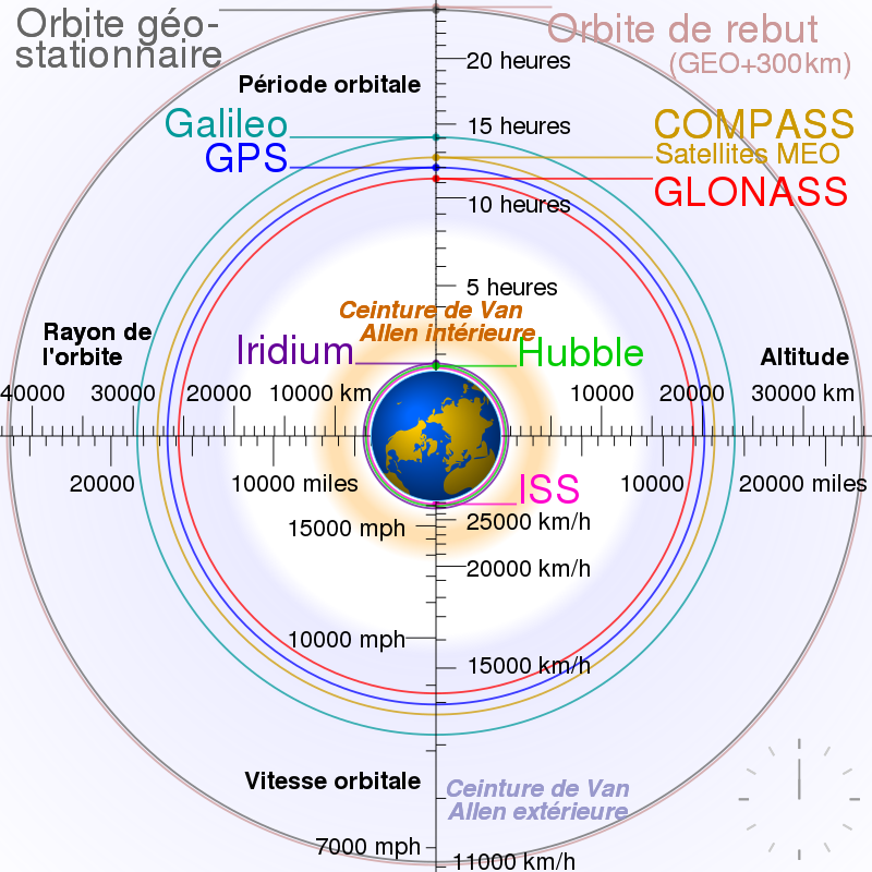
GNSS signals are received by the antenna and then processed by the receiver to measure pseudodistances, the distance between a GNSS satellite and the user’s receiving antenna. These are affected by the various errors listed below:
-
Satellite orbits,
-
Satellite clocks,
-
Code and phase biases,
-
Ionosphere,
-
Troposphere
The accumulation of errors in the pseudodistances results in a position with an accuracy of several metres. To achieve high centimetre accuracy, the above errors need to be corrected.
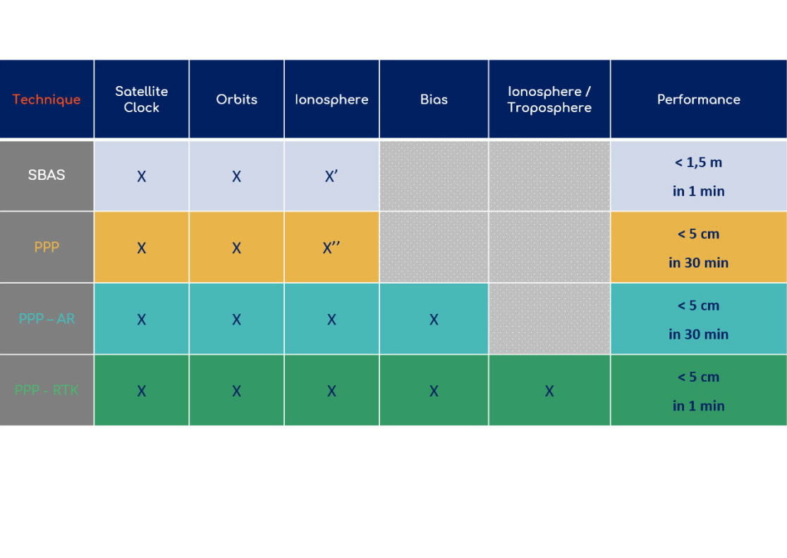
To do this, there are real-time GNSS correction services such as TERIA. TERIA will resolve the errors by providing various types of correction, enabling pseudorange measurements to be corrected and centimetre measurements to be obtained.
- DGPS (Differential Global Positioning System)
- RTK (Real Time Kinematic)
- NRTK (Network Real Time Kinematic)
- PPP (Precise Point Positioning)
- PPP-RTK
- SBAS (Local Based Augmentation System)
OSR
SSR
DGPS
PPP
RTK
PPP-RTK
NRTK
SBAS
OSR – Observation State Representation
Observation Space Representation, OSR, is the historical method used by GNSS correction service providers.
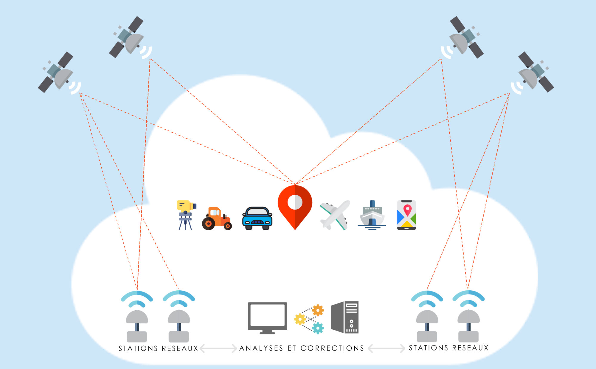
In NRTK mode, users send their approximate position to a correction center. This center then corrects the GNSS “observations” and returns the corrected raw data, from a physical or virtual reference station, with corrected pseudoranges of centimetric accuracy.
This method makes it possible to provide personalized corrections to each user through two-way communication over the Internet.
OSR thus enables real-time positioning with centimetric accuracy.
However, this method requires a bidirectional Internet link using the NTRIP protocol, and is not designed to handle a large number of users simultaneously, as the bandwidth used increases with the number of connections.
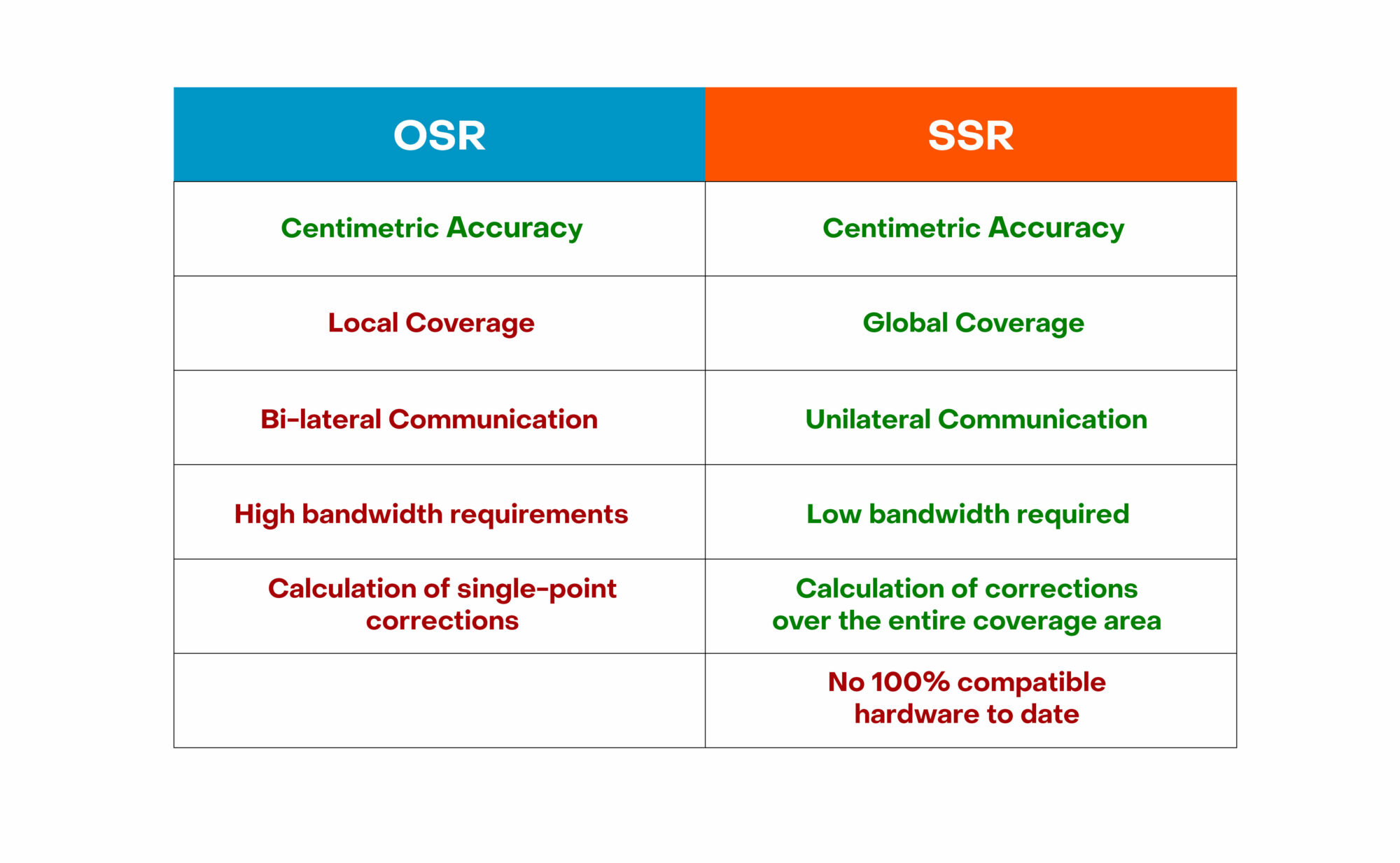
Comparing the advantages and disadvantages of OSR and SSR
The OSR and SSR operate using different methods. As a result, there are certain inherent limitations.
Compared with SSR, the OSR uses a single physical or virtual reference station (NRTK) to achieve centimetric accuracy.
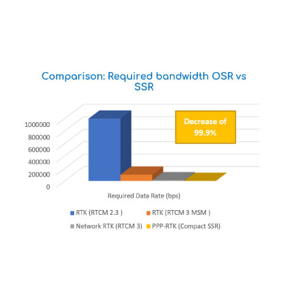
In addition, the OSR system is based on the exchange of data between the user and the computer centre. The size of the packets exchanged is very large. This is why the bandwidth used is also significant (see table).
If the station is physical (DGPS, RTK), the user is dependent on it. The further away they are from their position, the less accurate they will be.
Similarly, if the user moves, he will either have to reconnect to a new station or, if the station is virtual(NRTK), re-generate a new virtual station. Depending on the correction provider, this change may be more or less rapid, resulting in a micro outage of a few seconds.
This is why this correction method is preferred for local use.
Estimated bandwidth for a coverage area of 400,000 km², with 14 GPS satellites
These constraints prevent the development of similar systems for large-scale industrial applications. This is where SSR makes all the difference.
SSR revolutionises the market by being virtually unconstrained for industrial deployment.
Developed from the outset for large-scale applications, the SSR overcomes the limitations of theOSR. It offers centimetric accuracy over a wide coverage area, uses low bandwidth, and operates without the user having to transmit any information (for example, without a SIM card). The flow of information is therefore unilateral.
OSR
- Topography – Expert Surveyors
- Agriculture ( self-steering tractors, weeding robots…)
- Topographic drones
- Automated public works vehicle
SSR
- Automotive
- Public transport (trams, trains…)
- Delivery drones
- Operated objects
However, SSR presents a major obstacle: as the latest generation of GNSS corrections, there is as yet no fully SSR-compatible receiver. Each supplier uses its own protocol and format, and the lack of a standard is delaying widespread deployment.
While there are plans to define an open standard for high-precision GNSS positioning, this has not yet become a reality.
In order to benefit from this service, users will have to invest in new receivers, which will only be available in a few years’ time.
SSR is very promising, but it will be a long time before we see the full benefits of high-precision GNSS in the industry.
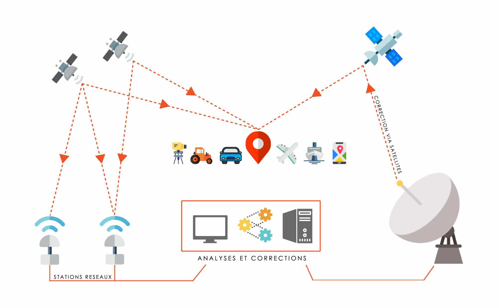
TERIA network: a network combining OSR and SSR
The TERIAsat advantage
TERIA offers both OSR and SSR services according to the needs and requirements of its customers.
The advantage of OSR services (DGPS -RTK – NRTK) with TERIA is that the density of stations in the area covered by the network is such that service availability is almost permanent (> 99% since 2012). What’s more, centimetric accuracy is guaranteed regardless of the user’ s position.
TERIA also offers its users SSR services (PPP – PPP-RTK) using satellite transmission of corrections in particular, thanks to its TERIAsat technology.
In order to receive satellite corrections and avoid white zones, the user’s receiver must be L-band compatible. However, this requires additional investment if your equipment is not.

To facilitate access to this technical innovation, TERIA has launched the TERIAsat terminal.
The TERIAsat Terminal includes a satellite antenna, a SIM card internet connection and a Wi-Fi/Bluetooth antenna. The client receiver connects via Wi-Fi/Bluetooth to receive the terminal’s corrections, which are received either via satellite or the Internet.
Users benefit from the advantages of both OSR and SSR on their current equipment, with the terminal providing the best available service to their mobile receiver without having to change their configuration.
